|
Peteroa:
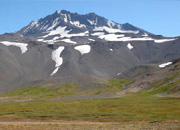
The
Peteroa Volcano is a pyramidal cone
that constitutes the highest point
of the Maule Region, with an altitude
of 4100 mts. located at the border
with Argentina, in which they also
call this volcano, Volcan Azufre
and forms volcanic complex Planchón-
Peteroa, with several craters between
the two main summits, Planchón and
Peteroa.
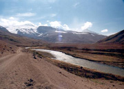
In
the surrounding area several glaciers
exist. They give birth to the Rio
Claro that is joined by the Rio
Teno in Los Queñes and part of the
larger river basin of the Rio Colorado.
On the Argentine side, the Rio Valenzuela,
that later is transformed into the
Rio Grande.
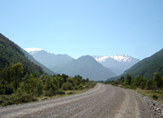
Aproach
From the base camp located at the
foot of Planchón you should continue
towards the south slope of the mountain
about 10 km. arriving at the feet
of the volcano by the sector northeast
about 3000 mts. After another 2
hours 45 minutes.
Important Note:The
times given are approximate depending
on the people of the expedition.
In summer you must consider allowing
for more time.
More Information in:
http://www.andeshandbook.com/
|